New Political Map Of India
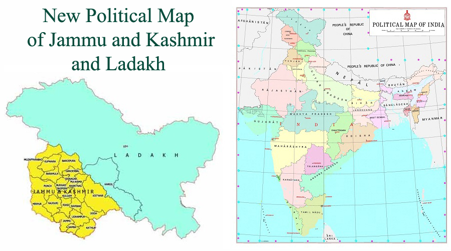
After the formation of separate union territories of Jammu and Kashmir and Ladakh, the Government of India released a new map of the country on Saturday 2nd November, which shows 28 states and nine union territories.
Ladakh consists of two districts Kargil and Leh. While 22 districts have been included in the union territory of Jammu and Kashmir. In a gazette notification, the government has also compiled the areas of Leh district, Gilgit, Gilgit Wazarat, Chilas, tribal areas, and Leh and Ladakh, excluding the present area of Kargil.
This map also shows parts of Pakistani occupied Kashmir (PoK) in the Kashmir region. The newly released map depicts the division of the erstwhile state of Jammu and Kashmir. It surprisingly covers three PoK districts Muzaffarabad, Panch, and Mirpur. This order has been called Jammu and Kashmir Reorganization (removing difficulties) Second Order-2019.
The map of the Jammu and Kashmir Union Territory consists of 22 districts Kathua, Jammu, Samba, Udhampur, Doda, Kishtwar, Rajouri, Reasi, Ramban, Poonch, Kulgam, Shopian, Srinagar, Anantnag, Budgam, Pulwama, Ganderbal, Bandipora, Baramulla, Kupwara, Muzaffarabad and Mirpur.
In 1947, there were 14 districts in the state of Jammu and Kashmir. These included Kathua, Jammu, Udhampur, Reasi, Anantnag, Baramulla, Poonch, Mirpur, Muzaffarabad, Leh and Ladakh, Gilgit, Gilgit Vajrat, Chilhas, and tribal areas.
The Union Territory of Ladakh will comprise of Kargil District which is carved from Leh and Ladakh district and Leh which comprise Gilgit, Gilgit Wazarat, Chilhas, Tribal Territory, and the remaining areas of Leh & Ladakh after carving Kargil.
On the recommendation of Parliament, President Ram Nath Kovind effectively abolished Article 370 in the Indian Constitution in August. Jammu and Kashmir ceased to exist as a state on 31 October and were officially divided into two union territories, Jammu and Kashmir and Ladakh.
Suggested Read: Republic of India

